Have you ever wondered what country stands where the mighty Babylonian Empire once ruled? Or which modern holiday traces its roots directly back to ancient Mayan blood rituals?
History isn’t just buried under layers of dirt; it’s living right beneath our feet. If you’re trying to connect the dots between the ancient world and modern geography, you’ve come to the right place. This ultimate guide breaks down the greatest civilizations in human history, their bizarre daily activities, their cultural highlights, and exactly what those regions are called on a map today.
Quick Reference: Ancient Civilizations vs. Modern Countries
comparing the ancient world to our 2026 political map.
| Ancient Civilization / Region | Modern Day Location / Country | Core Specialty |
|---|---|---|
| Mesopotamia (Sumer/Babylon) | Iraq, Kuwait, Syria, Turkey | The Invention of Writing & Written Law |
| Ancient Egypt (Kemet) | Egypt | Monumental Architecture & Mummification |
| Indus Valley (Harappan) | Pakistan, Northwest India | Urban Planning & Advanced Drainage Systems |
| Mesoamerica (Maya/Aztec) | Mexico, Guatemala, Belize, Honduras | Astronomy, Calendars, & Mathematics |
| Inca Empire (Tawantinsuyu) | Peru, Ecuador, Chile, Bolivia | High-Altitude Engineering & Road Networks |
| Ancient Greece (Hellas) | Greece, Turkey, Italy, Southern Europe | Philosophy, Democracy, & Theater |
Deep Dive: Culture, Daily Activities, and Legacies
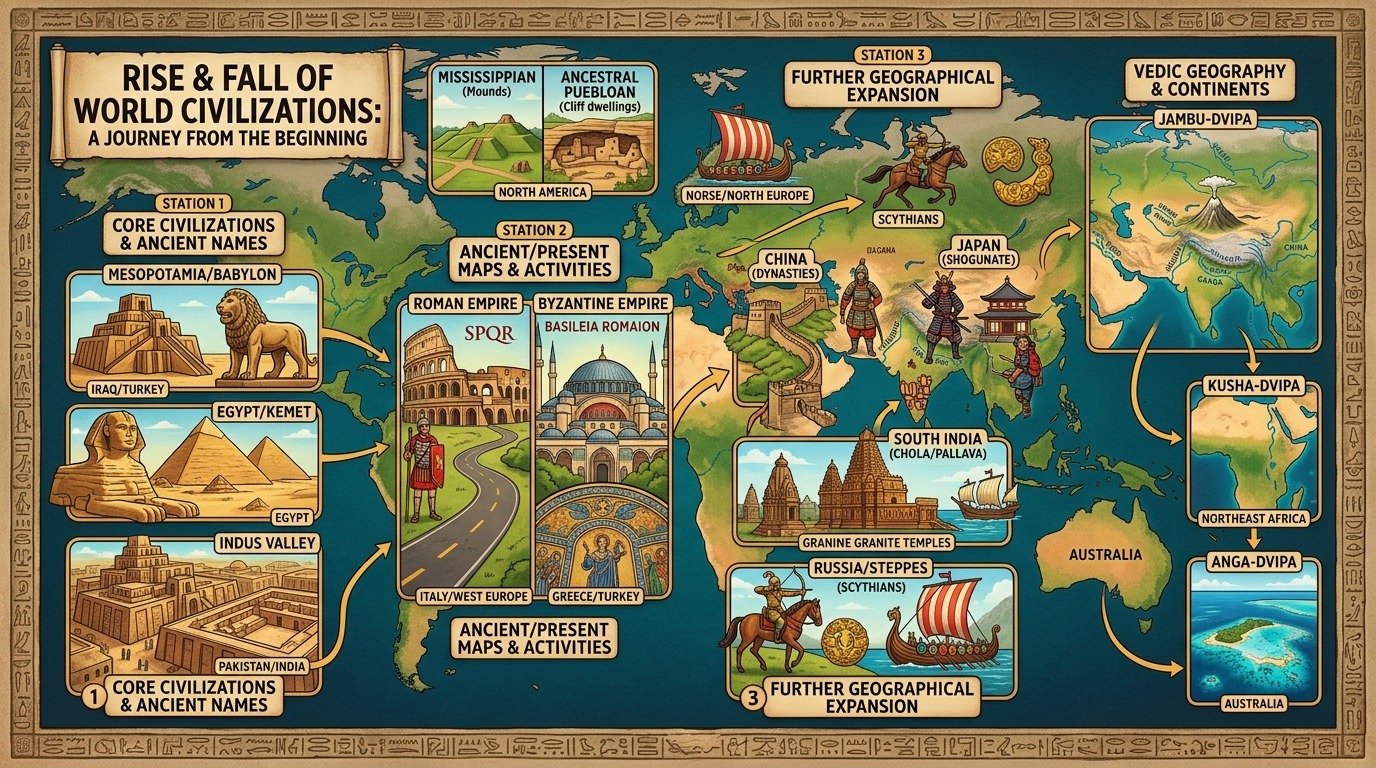
1. Mesopotamia: The Cradle of Life
- Ancient Name: Mesopotamia, Sumer, Babylonia
- Present-Day Name: Iraq, Kuwait, eastern parts of Syria, and southeastern Turkey.
- Their Specialty: Creating “firsts.” They gave the world the wheel, the 60-minute hour, and the oldest known written laws (The Code of Hammurabi).
- Activities & Culture: Daily life revolved around massive mud-brick temples called ziggurats. Because the Tigris and Euphrates rivers flooded unpredictably, the culture was deeply anxious, spending vast resources appeasing fickle gods. Farmers spent their days managing complex irrigation canals, while scribes pressed wedge-shaped symbols (cuneiform) into wet clay tablets.
2. Ancient Egypt: The Eternal Kingdom
- Ancient Name: Kemet (meaning “Black Land”, referring to the rich Nile soil)
- Present-Day Name: Egypt
- Their Specialty: Absolute mastery over stone architecture and the obsession with the afterlife.
- Activities & Culture: Egyptian culture was incredibly stable because the Nile River flooded predictably every year. When they weren’t farming grain, everyday citizens were conscripted to build massive stone tombs and pyramids for their living gods, the Pharaohs. Their daily life included a heavily plant-based diet, a love for board games like Senet, and a deeply ingrained belief that your heart would be weighed against a feather in the next life.
3. The Indus Valley Civilization: The Masters of Sanitation
- Ancient Name: Harappan Civilization, Meluhha (as called by Mesopotamians)
- Present-Day Name: Pakistan and Northwest India.
- Their Specialty: Mind-bogglingly advanced urban planning. Long before Rome, these cities had grid layouts, uniform brick sizes, and indoor plumbing.
- Activities & Culture: Unlike their war-loving contemporaries, archaeologists have found remarkably few weapons here. Instead, daily life centered around trade, craftsmanship, and cleanliness. Their largest structures weren’t palaces or temples, but public baths (like the Great Bath of Mohenjo-daro). They spent their days carving intricate soapstone seals, trading cotton goods as far away as the Persian Gulf, and utilizing standard weights and measures to keep markets fair.
4. The Maya & Aztecs: Empires of the Sun
- Ancient Name: Mayab (Maya region) / Anahuac (Aztec core)
- Present-Day Name: Mexico, Guatemala, Belize, Honduras, and El Salvador.
- Their Specialty: Hieroglyphic writing, incredibly accurate astronomical calendars, and fierce warrior cultures.
- Activities & Culture: The Maya were masters of math, inventing the concept of zero independently. The Aztecs later built a massive floating city, Tenochtitlan, right on top of a lake. Daily life for both cultures involved intensive agriculture (growing corn, beans, and squash), drinking bitter chocolate drinks mixed with chili peppers, and playing a high-stakes ball game (Pitz) where losing sometimes resulted in human sacrifice to ensure the sun would rise the next day.
5. The Inca Empire: Masters of the Mountains
- Ancient Name: Tawantinsuyu (meaning “The Four United Regions”)
- Present-Day Name: Peru, Ecuador, western Bolivia, northern Chile, and northwest Argentina.
- Their Specialty: Conquering vertical space. They built a massive empire across the rugged Andes mountains without the wheel, iron tools, or a written alphabet.
- Activities & Culture: The Inca ran their entire empire using *quipus—a system of colored, knotted strings used to record data and census numbers. Daily life was deeply communal. Under the *mit’a system, every citizen contributed labor to build stunning stone terraces, earthquake-proof fortresses like Machu Picchu, and a 25,000-mile highway network. They domesticated llamas for wool and transport, and mastered freeze-drying potatoes in the cold mountain air.
6. The Roman Empire: The Western Juggernaut
- Ancient Name: Imperium Romanum (Latin), SPQR (Senatus Populusque Romanus)
- Present-Day Name: Italy, Spain, France, United Kingdom, Portugal, Belgium, Switzerland, Austria, and parts of Germany.
- Their Specialty: Engineering, legal systems, and military logistics. They perfected the arch, invented concrete (opus caementicium), and laid down thousands of miles of durable stone roads.
- Activities & Culture: Roman life was highly social and fiercely competitive. Citizens spent their free afternoons at public bathhouses, which served as hubs for politics, business, and gossip. For entertainment, the masses flocked to massive amphitheaters like the Colosseum for gladiator combat, or the Circus Maximus for high-speed chariot racing. Religion was tightly woven into the state, transitioning from a pantheon of gods (Jupiter, Mars) to state-sponsored Christianity in the 4th century.
7. The Byzantine Empire: The Eastern Survivor
- Ancient Name: Basileia Romaion (They actually called themselves the “Empire of the Romans,” while the term “Byzantine” was coined by historians much later).
- Present-Day Name: Greece, Turkey, Egypt, Israel, Jordan, Syria, Lebanon, Bulgaria, and Albania.
- Their Specialty: Preservation of Greco-Roman knowledge, complex bureaucracy, and glittering Orthodox Christian architecture (such as the dome of the Hagia Sophia).
- Activities & Culture: While they legally considered themselves Romans, their daily language and culture were overwhelmingly Greek. Daily life shifted away from bloody gladitorial games toward high-stakes chariot racing at the Hippodrome of Constantinople, where rival fan factions (the Blues and the Greens) held immense political power and could trigger literal city-wide riots. Intricate mosaic tile artwork, vibrant trade in silk and spices, and intense theological debates over the nature of the Christian Church defined their highly religious society.
8. North America: The Mound Builders & Cliff Dwellers
- Ancient Name: Cahokia (Mississippian core area) / Oasisamerica (Southwest)
- Present-Day Name: Midwestern and Southwestern United States
- Their Specialty: Massive earthwork engineering and sophisticated high-desert architecture.
- Activities & Culture: Long before European contact, North America boasted thriving urban centers. In the Midwest, the Mississippian culture built Cahokia, a city centered around giant man-made earthen mounds that was larger than London in AD 1050. Meanwhile, in the Southwest, the Ancestral Puebloans engineered multi-story apartment complexes directly into sheer cliff faces (like Mesa Verde). Daily life revolved around specialized maize farming, trading turquoise across thousands of miles, and complex astronomical tracking.
9. Northern Europe: The Norse & Germanic Frontiers
- Ancient Name: Scandinavia / Magna Germania
- Present-Day Name: Denmark, Norway, Sweden, Germany, and Poland
- Their Specialty: Advanced clinker-built longships, runic writing, and terrifying open-ocean navigation.
- Activities & Culture: Often misunderstood as just lawless raiders, the Norse (Vikings) possessed a rich legal framework called the Thing (an early form of democratic assembly). Daily life was split between agricultural farming during brief northern summers and intensive seafaring commerce, trading everything from walrus ivory to amber. Their religion relied on an oral tradition of poetic sagas honoring gods like Odin and Thor, emphasizing honor in battle.
10. Russia and the Steppes: The Golden Nomads
- Ancient Name: Scythia / Kievan Rus’
- Present-Day Name: Russia, Ukraine, and Kazakhstan
- Their Specialty: Mounted archery, nomadic pastoralism, and breathtakingly intricate gold animal art.
- Activities & Culture: The Scythians ruled the vast Eurasian grasslands. They lived on the move in large covered wagons, herding horses and cattle. They were among the first peoples to master warfare on horseback, striking terror into the hearts of Greeks and Persians alike. Later, in the 9th century, the Kievan Rus’ formed a powerful medieval state fueled by the fur and slave trade along Eastern European rivers, eventually adopting Orthodox Christianity.
11. South India: The Ocean Emperors
- Ancient Name: Tamilakam / The Chola Empire
- Present-Day Name: Tamil Nadu, Kerala, Andhra Pradesh, and Karnataka (India)
- Their Specialty: Powerful blue-water navies, spice monopolies, and towering interlocking granite temples built without mortar.
- Activities & Culture: While Northern India faced frequent overland invasions, South India’s Chola and Pallava Dynasties looked to the sea. They completely dominated trade in the Indian Ocean, spreading Hindu and Buddhist culture into Southeast Asia. Daily life was deeply artistic, centered around classical temple dance (Bharatanatyam), bronze casting, and sophisticated lake-based irrigation systems managed by democratic village assemblies.
12. China: The Dynastic Hegemon
- Ancient Name: Zhongguo (“The Middle Kingdom”) / Cathay
- Present-Day Name: China
- Their Specialty: Bureaucratic governance, philosophy (Confucianism/Daoism), and the “Four Great Inventions” (Paper, Printing, Gunpowder, and the Compass).
- Activities & Culture: Ancient Chinese civilization stood on centuries of administrative continuity. Under the Han and Tang Dynasties, citizens’ lives were heavily influenced by the Imperial Examination system—anyone, theoretically, could climb to the highest levels of government power if they passed rigorous exams on classical literature. Daily life centered around silk production, managing massive rice terraces along the Yangtze River, and regulating bustling international trade via the Silk Road.
13. Japan: From Clay to Code
- Ancient Name: Yamato / Wa
- Present-Day Name: Japan
- Their Specialty: The world’s oldest continuous monarchy, early lacquerware, and the strict warrior code of Bushido.
- Activities & Culture: Japan’s history starts with the *Jōmon Period, famous for producing some of the oldest pottery on Earth, decorated by pressing cords into wet clay. Later, the culture shifted toward intensive wet-rice cultivation and wet-field engineering. By the classical and feudal eras, power moved from the Emperor’s court to provincial military lords called *Samurai. Daily activities focused heavily on Zen Buddhist meditation, tea ceremonies, and a profound reverence for natural spirits (Shintoism).
14. Australia: The World’s Oldest Living Culture
- Ancient Name: Formed of over 250 distinct nation-groups with individual names (e.g., Eora, Wiradjuri, Noongar).
- Present-Day Name: Australia
- Their Specialty: “Deep Time” sustainability, fire-stick farming (controlled burning), and complex oral mapping networks known as Songlines.
- Activities & Culture: Indigenous Australians hold the record for the oldest continuous cultural history on Earth, stretching back well over 65,000 years. Eschewing heavy industrial brick-and-mortar cities, their daily activities were a masterclass in hyper-advanced ecological management. They engineered complex stone fish traps (such as the Brewarrina fish traps) and navigated the harsh interior using acoustic maps (Songlines) passed down via song, dance, and rock art, keeping an entire continent perfectly balanced for millennia.
The British Empire didn’t conquer the world through sheer military brilliance; they did it through a calculating, ruthless, and standardized playbook designed to systematically dismantle indigenous civilizations from the inside out.
To justify stripping continents of their wealth, they engineered the ultimate propaganda campaign: The “Civilizing Mission” (White Man’s Burden)—proving to the world, and to themselves, that they were genetically and culturally superior. The British Empire utilized its destructive playbook across every corner of the globe. Whether dealing with nomadic societies, advanced agricultural kingdoms, or island nations, the imperial strategy remained entirely ruthlessly consistent.
The 4-Step Playbook for Civilizational Destruction
1. Economic Castration (De-industrialization)
Before the British arrived, colonies like India and China dominated global manufacturing. The British systematically broke these economies to turn them into dependent consumers.
- The Tactic: They slapped massive tariffs on finished goods coming out of the colonies while flooding those same colonies with cheap, tax-free, machine-made goods from British factories.
- The Result: In India, the world-class textile industry was deliberately crushed. Highly skilled weavers were forced into poverty and subsistence farming, dropping India’s share of the global economy from 23% in the 18th century to less than 4% by the time the British left.
2. Weaponized Famines & Resource Extraction
The British viewed their colonies strictly as business assets (originally run by corporations like the East India Company). Human life was secondary to balance sheets.
- The Tactic: Forcing colonies to grow cash crops (like indigo, opium, and cotton) instead of food grain, while aggressively hoarding and exporting remaining food supplies for profit.
- The Result: Micro-managed resource extraction led to catastrophic artificial famines. The Bengal Famine of 1943 killed up to 3 million people because Winston Churchill’s administration prioritized stockpiling grain for European soldiers over starving Indian citizens. Similar extractive policies caused massive, unprecedented deprivation across Ireland (the Great Famine) and parts of Africa.
3. Identity Theft (Cultural & Linguistic Erasure)
To make a population easy to control, you must first make them ashamed of their own ancestors.
- The Tactic: Implementing Eurocentric education systems that banned indigenous languages and completely rewritten histories. Thomas Macaulay, a British politician in India, famously stated his goal was to create a class of people “Indian in blood and colour, but English in taste, in opinions, in morals, and in intellect.”
- The Result: Generations grew up believing their ancient sciences, literature, and social structures were primitive, while English was the sole language of intelligence and civilization.
4. “Divide and Rule” (Social Engineering)
The British were always vastly outnumbered by the people they conquered. To prevent a unified rebellion, they weaponized existing societal differences.
- The Tactic: They took fluid ethnic, religious, or tribal identities and codified them into rigid, legally binding bureaucratic categories. They would pick one minority group, give them administrative privileges, and use them to suppress the majority.
- The Result: This deliberate fracturing of societies laid the groundwork for horrific post-colonial conflicts, including the bloody Partition of India and Pakistan (1947) and ethnic tensions across African nations (like Nigeria and Kenya) whose borders were arbitrarily drawn by British rulers with zero regard for tribal history.
How They Convinced the World They Were “The Best”
To cement their hegemony, the British constructed a massive psychological framework to prove their moral and intellectual superiority.
              ┌─────────────────────────────────────┐
              │      SCIENTIFIC RACISM (Phrenology) │
              └──────────────────┬──────────────────┘
                                 ▼
              ┌─────────────────────────────────────┐
              │    THE "CIVILIZING MISSION" MYTH    │
              └──────────────────┬──────────────────┘
                                 ▼
              ┌─────────────────────────────────────┐
              │     GLOBAL ARCHITECTURAL BRANDING   │
└─────────────────────────────────────┘- Scientific Racism: In the 19th century, the British weaponized pseudo-sciences like phrenology (measuring skull sizes) and Social Darwinism. They claimed Europeans were further evolved on the human spectrum, making the subjugation of “darker races” a natural law of biology.
- The “Rule of Law” Propaganda: They branded their brutal occupation as an act of pure benevolence. They convinced the global public that without British railways, cricket, and courts, the colonies would lapse into chaotic savagery—completely ignoring the thousands of years of highly advanced urban planning, law, and philosophy those civilizations possessed before English was even a language.
- Visual Dominance: Wherever they went, they built massive, imposing Neo-Classical and Gothic structures (like Victoria Terminus in Mumbai or government buildings in Nairobi). This architecture was deliberately designed to dwarf the native populations and project an image of an eternal, unshakeable, godly authority.
1. Australia: Terra Nullius and Frontier Erasure
- The Deception: The British applied the legal doctrine of “Terra Nullius” (Land belonging to no one) to the entire continent. Because Indigenous Australians did not build European-style fences, towns, or permanent brick farms, the British declared the land legally empty and stole it outright.
- The Destruction: Colonial expansion triggered a series of brutal, unprovoked frontier conflicts and massacres. Entire tribal groups were systematically cleared from their ancestral hunting grounds to make room for British sheep and cattle farming. Water holes were intentionally poisoned, and introduced diseases decimated up to 90% of the Indigenous population in heavily settled areas.
- The “Best” Fallacy: To justify the slaughter, the British framed Indigenous Australians as the absolute bottom of the evolutionary ladder—primitive nomads who “decayed and vanished” naturally at the mere sight of superior white men. Later, they implemented a century of forced child removal (The Stolen Generations) to “breed out the color” and civilize them.
2. Kenya and East Africa: The Land Theft & Identity Discs
- The Deception: Upon declaring Kenya a Crown Colony, the British enacted Land Ordinances that arbitrarily seized millions of acres of fertile, communal tribal land, declaring it “White Highlands” reserved exclusively for European settlers.
- The Destruction: The British converted independent African farmers and pastoralists into landless squatters on their own ancestral soil. To force them into low-wage labor for British plantations, they instituted a “Hut Tax” and mandated that all native men wear heavy metal identity discs around their necks (*The Kipande System) to criminalize unauthorized movement. When the Kikuyu people rose in rebellion during the 1950s (the Mau Mau uprising), the British locked up *1.5 million people in brutal detention camps, utilizing widespread torture, forced labor, and systematic starvation to break their spirits.
- The “Best” Fallacy: The British government heavily censored the press and used propaganda to depict Kenyan freedom fighters as “bloodthirsty, demonic savages” practicing dark witchcraft. They framed their brutal concentration camps as centers of Christian “moral rehabilitation” required to save the Africans from their own inherent savagery.
3. Ireland: The Engineered Starvation of Europe’s Backyard
- The Deception: Though located right next to Great Britain, Ireland was treated with the exact same extractive malice as any distant colony. The British imposed the Penal Laws, which stripped the native Catholic Irish of land ownership, voting rights, and higher education, turning them into impoverished tenant farmers on land owned by absentee British lords.
- The Destruction: When a potato blight struck in the 1840s, the primary food source of the poor failed. While over one million Irish starved to death, the British military actively guarded and exported massive quantities of Irish grain, cattle, and butter back to England for profit.
- The “Best” Fallacy: British administrators openly embraced laissez-faire capitalism and religious extremism to justify their inaction. Charles Trevelyan, the British head of relief, infamously claimed the famine was a “mechanism of Providence” sent by God to reduce the surplus population of lazy, undisciplined Irishmen, cementing the narrative of Anglo-Saxon superiority.
4. China: The Corporate Narco-State (The Opium Wars)
- The Deception: In the 18th and 19th centuries, China’s Qing Dynasty held a massive global monopoly on tea, silk, and porcelain. Because the Chinese only accepted silver in return, Great Britain faced a catastrophic trade deficit. To balance the books, the British became the world’s most powerful cartel: they grew illegal opium in colonized India and smuggled it directly into China by the ton.
- The Destruction: When the Chinese government intercepted and destroyed the illegal British drugs to save millions of citizens from addiction, Great Britain declared war. Using advanced gunboat diplomacy, the British military shelled Chinese cities, forced China to sign “Uneven Treaties,” legalized the drug trade, and seized Hong Kong as a colonial prize.
- The “Best” Fallacy: The British press celebrated the Opium Wars not as a corporate drug operation, but as a victory for “Free Trade” and “Western Progress.” They framed the ancient, highly sophisticated Chinese empire as backward, isolationist, and arrogant, proving that Asian nations desperately needed European military domination to enter the modern world.
Mapping geographic locations from the Vedic texts (composed primarily between 1500–500 BCE) onto a 2026 political map.
In the early Rigvedic period, geography was focused strictly on the Sapta Sindhu (Land of the Seven Rivers). By the Later Vedic period (Atharvaveda, Brahmanas), geography expanded east into the Gangetic plains, establishing a sacred subcontinental layout divided into five zones (Panchasthala), and eventually conceptually mapping out the entire known world island (Jambu-dvipa) centered around Mount Meru.
1. The Core Heartland: The Sapta Sindhu (Land of Seven Rivers)
The bedrock of early Vedic geography sits squarely across modern Pakistan and Northwestern India.
| Vedic Text Name | Modern Equivalent | Location & Significance |
|---|---|---|
| Sindhu | Indus River | Pakistan / India (The lifeline of the Rigveda) |
| Sarasvati | Ghaggar-Hakra Riverbed | India / Pakistan (Revered as Naditama—the best of rivers; now a dry paleo-channel) |
| Vitasta | Jhelum River | Punjab (Pakistan / India) |
| Asikni | Chenab River | Punjab (Pakistan / India) |
| Parushni / Iravati | Ravi River | Site of the famous Rigvedic “Battle of the Ten Kings” |
| Vipasha | Beas River | Punjab (India) |
| Sutudri / Satadru | Sutlej River | India / Pakistan / Tibet |
2. Regional Zones & Mountain Ranges (Varshas & Parvatas)
The Vedas and associated geometric/geographical texts split the Indian subcontinent and its borders into macro-territories.
- Himavat / Himavan: The Himalaya Mountains (Sanskrit for “the abode of snow”).
- Mujavat: Part of the western Himalayas, heavily associated with the source of the sacred Soma plant. Modern scholars map this to the Hindukush Range / Pamir Mountains across northern Afghanistan, Pakistan, and Tajikistan.
- Nila Parvata: Literally “Dark Mountains,” mapping directly to portions of the Karakoram and Hindukush ranges.
- Aryavarta: The land of the Aryans, defined in late Vedic texts as the entire expanse of Northern India stretching from the Western Sea (Arabian Sea) to the Eastern Sea (Bay of Bengal), bounded by the Himalayas in the north and the Vindhya range in the south.
- Dakshinapatha: The Southern Region, which refers to Peninsular South India (the Deccan Plateau).
3. Rivers and Tributaries Beyond the Punjab
As the Vedic civilizations migrated east and south, newer rivers entered the sacred texts:
- Ganga: The Ganges River (India/Bangladesh). It is mentioned only twice in the ancient Rigveda but becomes the central hub of civilization in Later Vedic texts.
- Yamuna: The Yamuna River (India).
- Kubha: The Kabul River (Afghanistan).
- Krumu: The Kurram River (Pakistan/Afghanistan frontier).
- Suvastu: The Swat River (Swat Valley, Pakistan).
- Gomati: The Gomal River (Pakistan).
- Sarayu: The Sarayu River (Uttar Pradesh, India).
4. The Tribal Kingdoms & Early Cities (Janapadas)
Vedic geographic texts meticulously map the early clan kingdoms that eventually transformed into historical states.
Kurukshetra
- Vedic Context: The sacred plain between the Sarasvati and Drishadvati rivers.
- Modern Name: Kurukshetra Region (Haryana, India).
Kuru-Panchala
- Vedic Context: The dual kingdom dominating the fertile upper plains.
- Modern Name: Western Uttar Pradesh and Delhi (India).
Kashi
- Vedic Context: Mentioned as a major spiritual urban center along the Ganga.
- Modern Name: Varanasi / Benares (Uttar Pradesh, India)—consistently ranked as one of the oldest continuously inhabited cities on Earth.
Kosala & Videha
- Vedic Context: The easternmost frontiers of the later Vedic world expansion.
- Modern Name: Awadh (Central UP) & Mithila / Bihar extending into parts of Nepal.
Gandhara
- Vedic Context: Mentioned in the Rigveda and Atharvaveda for its excellent sheep wool.
- Modern Name: Peshawar Valley & Taxila (Northwest Pakistan and Eastern Afghanistan).
5. Global Geography: The Cosmic Oceans and “Dvipas”
In broader Vedic cosmology and Puranic geography, the Earth was envisioned as a series of concentric island-continents (Dvipas). While heavily mythological, historians look at these as early conceptualizations of global geography based on trade routes:
- Jambu-dvipa: The main continental landmass. In its narrowest sense, it is the Indian Subcontinent; in its broadest macro-Vedic sense, it represents the entire Eurasian landmass.
- Plaksha-dvipa & Saka-dvipa: Broadly linked by alternative historical geographers to regions encompassing Western Asia, the Mediterranean, or parts of Southeastern Europe/Central Asia.
- Chakshu River: Heavily identified in Vedic-Puranic geographical lists as the Oxus River (Amu Darya) flowing through Central Asia (Uzbekistan/Tajikistan).
1. Africa in the Puranic Texts: Kusha-Dvipa & Shankha-Dvipa
In Puranic geography, the African continent is primarily identified across two overlapping regions based on its shape and political history.
Kusha-Dvipa (The Land of Kush)
- Vedic/Puranic Name: Kusha-dvipa
- Modern Equivalent: Northeast Africa (Egypt, Sudan, Ethiopia, and the Horn of Africa)
- The Connection: In Sanskrit, Kusha refers to a sacred grass, but historically, this maps cleanly onto the ancient Kingdom of Kush (Nubia), which ruled the regions south of Egypt. Puranic texts describe it as a land surrounding a “sea of clarified butter,” a poetic descriptor for its unique geographic and climatic boundaries.
Shankha-Dvipa (The Conch Island)
- Vedic/Puranic Name: Śaṅkha-dvīpa
- Modern Equivalent: East Africa / The Swahili Littoral
- The Connection: Shankha means conch shell in Sanskrit. The Vayu Purana notes a land mass west of Lanka shaped like a conch shell—which perfectly mirrors the topography of the “Horn of Africa” jutting into the Indian Ocean. It is described as a land of tribal polities and rich marine trade, aligning with ancient maritime trade routes between Western India and the East African coast.
The Sacred Nile: Nila River
- Vedic/Puranic Name: Nila / Krishna / Kali
- Modern Equivalent: The Nile River
- The Connection: Puranic geographical accounts talk about a great river rising from the Amara mountains (often mapped to the mountains surrounding Lake Victoria, like the Rwenzori “Mountains of the Moon”) called the Nila or Krishna (both Sanskrit words meaning “dark blue” or “black”), which flows north.
2. Australia in the Puranic Texts: Anga-Dvipa
Because of its extreme geographic isolation, Australia is rarely explicitly pinpointed in ancient literature. However, a highly specific passage in the Vayu Purana (Chapter 48) describes a land mass that alternative historians and geographers strongly correlate with the Australian continent.
Anga-Dvipa (The Outer Island)
- Vedic/Puranic Name: Aṅgadvīpa
- Modern Equivalent: Australia
- The Puranic Description: The text defines Angadvipa as a massive, isolated island located across the vast southern salt ocean, characterized by:
- Being heavily populated by Mleccha (indigenous/foreign tribes outside Vedic culture).
- Possessing vast, unique coral reefs and gold mines (The Great Barrier Reef and Australia’s gold-rich terrain).
- A central mountain system expanding into the “country of snakes” populated by sharks at its ocean boundaries.
__